Surface faults are a natural hazard that adversely affects structures of all types. Identification prior to development can minimize the financial effect on builders and developers.
Fault Facts
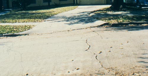
- A geological surface fault is a break in the land’s surface along which the ground on one side of the fault moves relative to the ground on the other side.
- Geological Surface Faults – a natural hazard along the Gulf Coast of Texas and Louisiana – have caused millions of dollars of damage over the years.
- Over 450 surface faults have been found in the upper Gulf Coast of Texas.
- More than 350 of these faults are in the Houston Metropolitan area, and many of these faults have been fully mapped.
- New surface faults are discovered each year, and it is likely that many unidentified faults will be found in the future.
- Buildings, houses, oil & gas pipelines, water & sewer lines, roadways, and airport runways are some of the structures which have been impacted by surface faults.
- Each year, buildings and houses have been inadvertently built upon previously identified faults.
- There is no effective, permanent foundation repair for buildings that have been damaged by faulting.
- Individual faults can be more than 10 miles long, and zones of multiple faults can extend more than 30 miles.
- A faults movement rate can vary over time, and a fault that is presently not moving, or is moving slowly, can begin moving at a faster rate over a relatively short period of time.
- The risk of being impacted by faulting can be minimized by determining whether a fault is present prior to development and construction.
- Faults are often not readily detectable, and identification of them usually requires the expertise of geoscientists.
Fault Detection
Identification of subtly expressed faults requires both the expertise of geoscience professionals and an adherence to the fault investigation guidelines established by the Houston Geological Society. These guidelines are incorporated in the rigorous program that Terrain Solutions Inc. (TSI) employs in it’s fault investigations.
TSI’s investigation of surface faults incorporates the following procedures:
PHASE I investigation (detection of faults that may be present)
- The review of published and unpublished literature regarding faulting in the Gulf Coast;
- review of available sub-surface data;
- Review of historical aerial photographs and available remote sensing imagery;
- A detailed field reconnaissance that is site specific and inclusive of the area surrounding the subject properly;
- Demarcation of an identified fault and it’s hazard zone when the surface expression of the fault has some definition.
PHASE II / III investigations (confirmation & delineation of faults when their surface expression is poorly defined)
- Drilling and geophysically logging 300′ boreholes to acquire information on sub-surface conditions that conclusively determines the presence and location of a surface fault;
- Demarcation of a fault hazard zone when a fault has been indentified.
Terrain Solutions Inc.’s Qualifications for Fault Studies
- Terrain Solutions Inc.’s (TSI) personnel have more than 30 years of experience with faulting in the Gulf Coast.
- TSI’s investigators are degreed geoscience professionals, and are licensed through the Texas Board of Professional Geoscientists, a state agency.
- TSI retains rigorous standards in it’s investigations, and follows the guidelines for fault investigations as established by the Houston Geological Society.
- TSI’s professionals have performed fault studies for both the public and private sectors. TSI’s personnel have performed fault studies for major public projects such as Katy Freeway (I-10) expansion, Hobby Airport’s concourse construction, and most of the major home builders and developers in Nortwest Harris County, Montgomery Country, and Brazoria County.